Planting Weather Forecast: More Moisture Will Continue to Slow Progress


It’s another wet planting forecast for Michigan this week.
We are starting things off on a good note with mostly dry weather for Saturday. However, this is just a gap between the rains that fell Friday and what is coming for Sunday. Still, we turn out mostly sunny for Saturday and should see good evaporation rates over the state. Clouds will build in the UP Saturday afternoon, and we won’t rule out showers over the western half of the UP, but the rest of us will wait to see clouds until the overnight Saturday night.
Showers develop overnight Saturday into Sunday with rain totals at .25”-.75” generally. There may be an embedded thunderstorm or two that bumps local rain totals above that range a bit, but nothing widespread. Moisture winds down Sunday afternoon.
We are precipitation free for Monday and most of Tuesday. Good drying will be seen. So, if you are in an area that got the lower end of any weekend rains, you may have a brief opportunity to get in the fields Tuesday afternoon. Showers begin in western parts of the UP Tuesday evening. The rest of us see rain develop overnight Tuesday night through Wednesday midday. Rain totals will be half to 1.5” with coverage at 100% of the state. A second round of moisture comes early Thursday morning through afternoon with an additional .25”-.75” and 80% coverage. This knock us out of the fields for a bit.
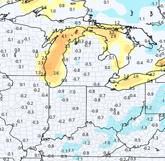
We are unsettled then to finish the 10 day forecast window. Next Friday, Saturday, and Sunday we do not see any big, well organized systems, but we also are going to have plenty of clouds holding over the region. We won’t rule out pop up showers meandering through over those days, with no more than 40% coverage, but rain totals that can be up to .25”. Clearly, with that kind of set up we will have slow drying over the state. Monday the 13th should set up with better sunshine, but clouds are still pesky. All in and all done for the week, we still have too much moisture to get overly excited about large scale planting…but, as the map below shows rain totals from this weekend through next weekend, the lowest rain totals for the period do favor the southern half to third of lower MI.
Extended Period:
Two systems in the extended 11-16 day forecast window. We start the period dry Monday and Tuesday but then see Rain showers develop with a system for Wednesday the 15th. That round produces .25”-.75” with coverage at 80%. After a dry Thursday period, another stronger system arrives for Friday the 17th with .25”-1” rains and coverage at 100%. We should finish the period dry from 5/18 though 5/20
Weeks 3 & 4:
Not a lot of good news in the far extended window either this time around. Precipitation will stay close to normal for the entire week 3 and week 4 outlook. Meanwhile, week 3 looks cool, meaning any potential drying will be slowed, and we bounce back only to “near normal” for week 4. The forecast is a bit concerning.
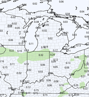
Week 3 Precipitation (Green = above normal, Brown = below)
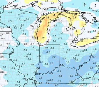
Week 3 Temperatures (yellow/orange = above normal, blue = below)
Week 4 Precipitation (Green = above normal, Brown = below)
Week 4 Temperatures (yellow/orange = above normal, blue = below)